
Page 161 - Combine
P. 161
International Journal of Trend in Scientific Research and Development (IJTSRD) @ www.ijtsrd.com eISSN: 2456-6470
and perennial snow is determined not by the amount of oil is 345.3 sq. km. With ice water flowing from so much area,
burned in the same year, but by the heat balance. In July- 138,000 hectares of land can be irrigated (I. A. Ilin).
September, the heat balance fluctuates less from year to year,
and is almost constant over the years. The annual flow of river water varies with the seasons,
which is one of the main factors determining the nature of
In terms of water resources, the total area of glaciers in the the seasonal load in the recreational-landscape areas.
basins of the Sokh, Isfayram, Isfara and Shohimardon rivers
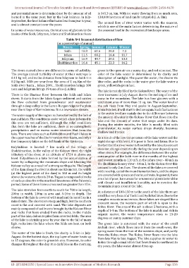
Table №1 Seasonal distribution of flow
(as a percentage of annual)
Rivers Spring Summer Autumn Winter
Sokh 10.3 61.6 20.8 7.3
Isfara 11.5 60.2 16.4 11.7
Isfayram 16.9 49.7 20.1 13.3
Shokhimardon 16.4 45.1 22.3 16.2
The rivers named above are different in terms of turbidity. green in the open air on a sunny day, and red at sunset. The
The average annual turbidity of water at their outcrops is color of the lake water is determined by its clarity and
0.13 kg m3, and in the distance from Isfayram to Sokh it is absorption of sunlight. The purer the water, the clearer its
0.2 kg m3. 500t per year from the area of 1 sq. Km of the blue color, and the rocks in the water give the lake water a
Sokh river basin. , Isfara 200t. , Shokhimardon brings 100 green, yellowish-green hue.
tons and Isfayram brings 39 tons of ice (I.A.Ilin).
The lake is mainly filled by the Koksu River. The water of the
There is the Shursuv River between the Sokh and Isfara river increases in July-August due to the melting of ice and
rivers. It starts from the Isfara-Logan sediment and carries snow in the mountains. The lake has four glaciers with a
the flow collected from groundwater and wastewater catchment area of more than 11 sq. km. The water level of
through a deep valley in the Guzan-Burgan ridge to the plain the ash rises from May and peaks in August-September.
near the village of Karimdevona. It is a low-water stream. From October, it will start to decline again. Such fluctuations
in the water level are mainly due to the difference between
The water supply of the region is characterized by the lack of
the amount of water in the Koksuv River that flows into the
natural lakes. The conditions under which a lake is formed in
lake and the amount of water that seeps under its dam.
this area are not sufficient. Although the relief conditions During the winter months, the lake is mostly filled with
that form the lake are sufficient, there is no atmospheric
groundwater, its water surface drops sharply, becomes
precipitation and no excess water reserves that form the
shallow and freezes.
lake. There are lakes such as Kolikubbon and Yashil lakes in
the upper reaches of the Shohimardon river basin, and only a As a result of the low temperature of the lake water and the
few temporary lakes on the left bank of the Syrdarya. rapid change of its level, it is poor in flora and fauna. Due to
the fact that the river water is flooded by the lake, its amount
Kolykubbon is located 7 km south of the village of
does not change dramatically during the year depending on
Shokhimardon, in the valley of the Koksuv river, the right
other rivers. For example, the difference between the water
tributary of the river, at an altitude of 1724 m above sea consumption of the Sokh river in the months of the highest
level. Kulyubbon is a lake formed by the accumulation of
and lowest months is 110 m3, in the Isfara river - 40 m3, in
water by collapsing the mountain slope and blocking the
the Shokhimardonsoy river - 14 m 3, in the Koksu river this
Koksuv valley as a result of a strong earthquake. The length amount is only 2 m 3 sec. The shores of the lake are covered
of the dam along the river is about one kilometer, the width
with rose hip, camel thorn and tamarisk bush, and the slopes
(at the highest point of the dam) is 160 m and its height
are covered with spruce and various shrubs. In general, there
above the water surface is 20 m. Tugan is composed of rocks
are a lot of poor, bare areas for ornamental plants behind the
of various sizes from the marbled limestones of the Paleozoic arid climate and insufficient humidity, not to mention the
period. Some of them have a cross section greater than 15m.
mountain slopes around the lake.
The lake stretches from north to south for 700m in length,
At a distance of 100-150 m to the south of the lake there are
200m in width, 130m in area and 5-10m in depth. The
small but very beautiful Yashil and Aydinkol lakes. Due to the
bottom of the lake is covered with mud and the sand lies in a complex mountainous terrain, these lakes are shaped like a
mixed state. The shores are steep and high, but the southern
crescent moon, the western part of which is open to the
coast is flat and covered with sand. The lake deposits are
Koksu River. The area of the ash is about 5 hectares, with a
mainly composed of sediments brought by the Koksuv River depth of 1-5 m. The bottom of the lake is muddy and rich in
and rocks that have eroded from the rocks. In the middle
organic matter, the water temperature rises to 15-20
part of the lake, dolomite piles form inverted folds. The area
degrees on sunny summer days.
of the lake is shrinking year by year due to the fall of many
light rocks into the lake where the folds are bent on both The green lake is saturated with the water of the small
shores. Archali river, which flows into it from the south-west, the
spring water from the foot of the western slope, and partly
The water of the lake is fresh, the clarity is 5-6m in July-
from the Koksu river. The Koksu River flows into the lake
August. On the hottest days, the top layer of water heats up from late May to late August. The lake supplies its water to
to 15 degrees, the color is greenish-airy. However, its color
Koksu through a small ditch that flows from the northeast. In
changes throughout the day. It is dark blue in the morning,
dry years, the lake water almost dries up.
ID: IJTSRD41158 | Special Issue on Innovative Development of Modern Research Page 156